PhotoCAD
Convert
Patent DrawingsArchitectureSurveyorsIndustrial DesignFashion DesignDigital FabricationHeritage & ArchaeologyIllustration
GalleryAPIPricing
Log in
PhotoCAD

Convert photos to CAD-ready vector files. DXF, DWG and SVG for manufacturing, CNC, IP work and architectural drawings.

Product

  • How it works
  • Convert
  • Gallery
  • Projects
  • Pricing
  • API

Solutions

  • Patent Drawings
  • Architecture
  • Surveyors
  • Industrial Design
  • Fashion Design
  • Digital Fabrication
  • Heritage & Archaeology
  • Illustration
  • Laser Cutting
  • Vinyl Cutting
  • CNC Routing
  • Plasma & Metal Art

Converters

  • Image to CAD
  • Sketch to CAD
  • PDF to DWG
  • JPG to DWG
  • PNG to DWG
  • Image to DXF
  • PDF to DXF
  • JPG to DXF
  • PNG to DXF
  • Raster to Vector
  • Trace Photo to Vector
  • Logo to Vector
  • Signature to Vector

Guides

  • Paper drawing to CAD
  • Floor plan to CAD
  • Photo to elevation drawing
  • Orthophoto to CAD
  • Archaeological drawing
  • Point cloud to CAD
  • Aerial image to CAD
  • Trace an image in AutoCAD
  • Image to SolidWorks

Company

  • About
  • Contact
  • Privacy Policy
  • Terms of Service
  • License
  • Trust & Security

© 2026 PhotoCAD. All rights reserved. PHOTOCAD® is a registered trade mark.

PhotoCAD for Surveyors

Convert Measured Surveys & Scans to CAD Drawings

Scanning a building takes a day; drawing it takes the office several more. PhotoCAD drafts the plans, elevations, and sections from your scan exports in minutes, and your team reviews and finishes them.

PhotoCAD drafts from the data your surveys produce

  • Plan slices

    A slice per floor from the registered cloud, in Cyclone, SCENE, RealWorks, ReCap, or Revit, drafted as the floor plan.

Create survey drawings from your scans

Four views, each an image exported from a laser scan or an orthophoto and converted in PhotoCAD. Drag the slider to compare.
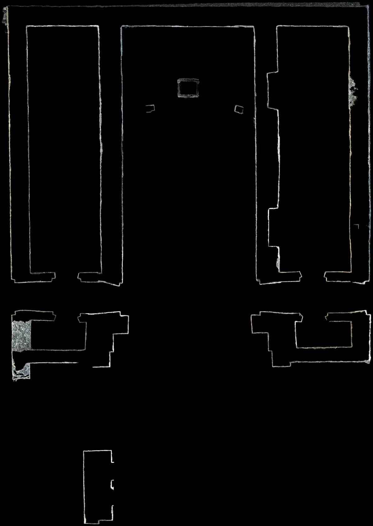
Original photo of Zobor Church Ruin Plan from a Laser Scan
Floor plan line drawing of the ruined church of St Joseph on Zobor Hill, Slovakia, drawn from a horizontal slice through a laser scan

Church ruin, Zobor Hill, Slovakia. Laser scan: P. Gawronek, CC BY 4.0, adapted.

Floor plans

A horizontal slice through the cloud. PhotoCAD draws both faces of every wall as closed outlines, with the openings.
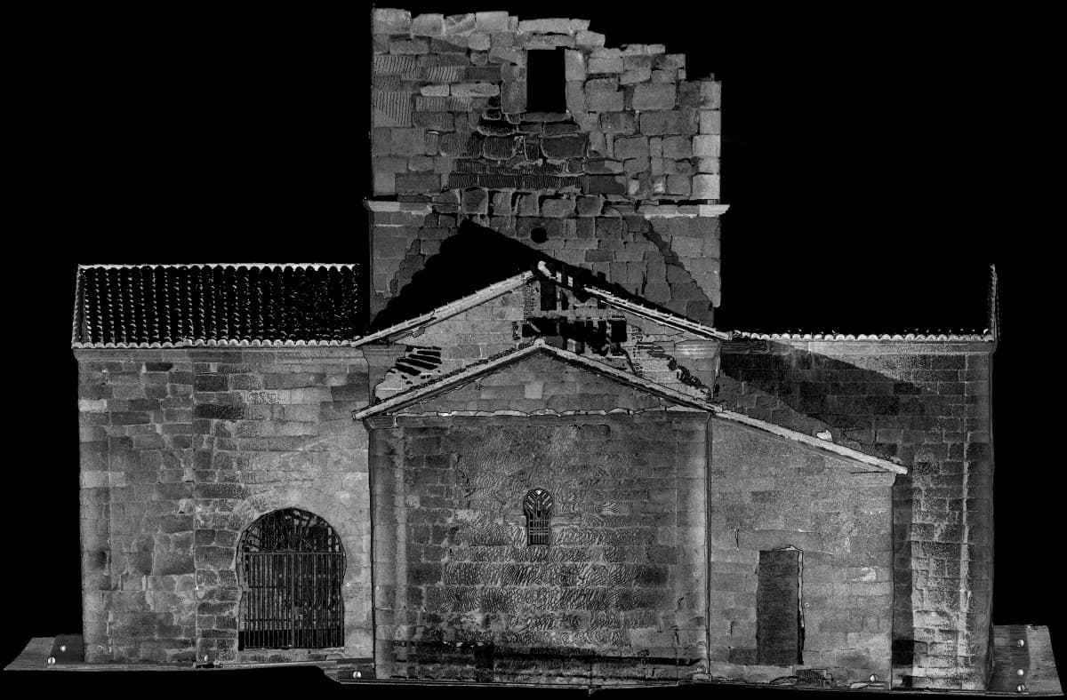
Original photo of Santa María de Melque Elevation from a Laser Scan
Elevation line drawing of the Visigothic church of Santa María de Melque, Spain, stone by stone, drawn from a laser scan intensity view

PhotoCAD compared with how survey drawings are drafted today

PhotoCAD compared with how survey drawings are drafted today
MethodTimeCostWhat you get
Your own CAD teamTimeHours per drawingCostDrafting day ratesTracing every wall, opening, and stone over the cloud. Often three days in the office for each day on site.
Point-cloud plug-inTimeHours, partly automaticCostFrom €1,200 a year per seatSnaps lines to clean edges inside CAD. Masonry, ruins, and anything irregular are still drawn by hand.
OutsourcingTimeDaysCostHundreds of dollars per elevationA drafting bureau works from your scan. Another round of checking before it goes to your client.

How PhotoCAD fits your workflow

Data, accuracy, and disclosure

How PhotoCAD handles your clients’ data, what sets the accuracy of a drawing, and how to describe the work to a client.

Data, accuracy, and disclosure
TopicHow PhotoCAD handles it
Client dataNever used to train AI models: not your images, not your drawings.
RetentionKept until you delete it. Deleting a conversion permanently destroys the image and the drawing within 30 days, and PhotoCAD Stealth deletes everything after 30 days by default.
Accuracy

In a measured building survey, or an as-built or existing-conditions survey, the fieldwork is the quick part. Scanning a building takes a day; turning the cloud into plans, elevations, and sections takes the office several days more, and that drafting is most of what the client pays for. It is also the part a small firm finds hardest to scale.

Tracing tools cannot help with that step: a point cloud or an orthophoto has no lines to follow. PhotoCAD works from a semantic understanding of the image. It recognizes the walls, openings, and masonry in the views your team already exports, a plan slice, an orthographic elevation, a section, and drafts each as clean, proportionally accurate linework in about a minute, set to scale, on your sheet, as DWG. Your drafters start from a draft and spend their time reviewing and completing it instead of tracing.

PhotoCAD does the initial drafting, not the survey, on an architectural survey and a heritage survey alike. Your team checks every drawing against the scan before it goes out, which is also what the RICS standard on AI expects of members. For confidential clients, PhotoCAD Stealth keeps processing on a contractual no-training chain and deletes on a schedule.

For the cleanest drafts

  • One view per image

    One floor, one wall, one cut. A whole building in one image keeps less detail than a close crop.

Ready to try it?

Export a view from a current job and see PhotoCAD draft it in a minute.
Your first 3 conversions are free — no card required.

Try it on one of your scansTalk to us about a project

Frequently Asked Questions

Typically several hours per drawing. Tracing a plan or an elevation over a point cloud takes several hours to a day by hand; PhotoCAD drafts the same view in about a minute. Your team still reviews and finishes each drawing, so the saving depends on the building and the level of detail. Try it on a current job: the first 3 conversions are free.

Yes, with any scanner, because PhotoCAD works from the images your software exports: Leica, FARO, Trimble, Z+F, NavVis, GeoSLAM, Matterport, or a phone. The point cloud guide shows where the image export is in each program.

PhotoCAD is an accurate drafting tool, not a surveying tool: the accuracy comes from your scan and your control. The drawing follows the exported view in proportion, is scaled from your surveyed dimensions, and is checked against the cloud by your team before it is issued.

Say that the linework was drafted with AI assistance from your scan data and checked by your team. The RICS professional standard Responsible use of artificial intelligence in surveying practice, mandatory for members from Mar 9, 2026, asks for disclosure to clients in writing and for due diligence on AI suppliers. Our AI supplier information sheet (PDF) answers the supplier questions point by point and suggests wording for your terms of engagement.

Yes. PhotoCAD never trains AI models on your images or drawings, and deleting a conversion permanently destroys the image and the drawing within 30 days. PhotoCAD Stealth, for confidential work, pins processing to a contractual no-training chain and deletes automatically. To set up a confidential workflow for a particular client, talk to us.

Keep exploring

Categories

Architecture & Buildings

Use cases

ArchitectureHeritage & Archaeology

Converters

PNG to DWGJPG to DWGPDF to DWGImage to CAD

Guides

Point cloud to CADOrthophoto to CADArchaeological drawingPaper drawing to CAD

Elevations and sections

Orthographic views of the cloud, in color or intensity, drafted as elevations and sections, one wall or cut per image.

  • Photogrammetric orthophotos

    Facade and floor orthophotos from your photogrammetry, drafted as measured elevations and plans.

  • Legacy drawings

    Old surveys and archive sheets, scanned or photographed, brought into CAD at real scale.

  • Santa María de Melque, Spain. Laser scan: J. Raimundo, CC BY 4.0, adapted.

    Elevations

    An intensity view of the front. PhotoCAD draws it stone by stone, with the door, the window, and the roof.
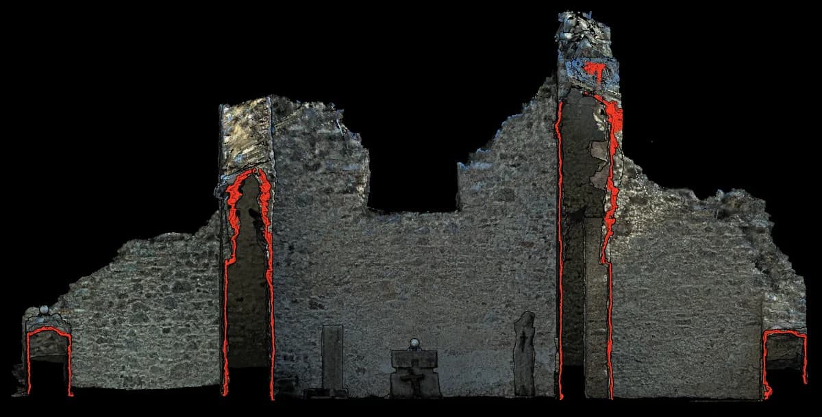
    Original photo of Zobor Church Ruin Section from a Laser Scan
    Section line drawing through the nave of the Zobor Hill church ruin, with the interior wall beyond, drawn from a laser scan

    Church ruin, Zobor Hill, Slovakia. Laser scan: P. Gawronek, CC BY 4.0, adapted.

    Sections

    A vertical cut through the building. PhotoCAD draws the cut walls and the interior face beyond.
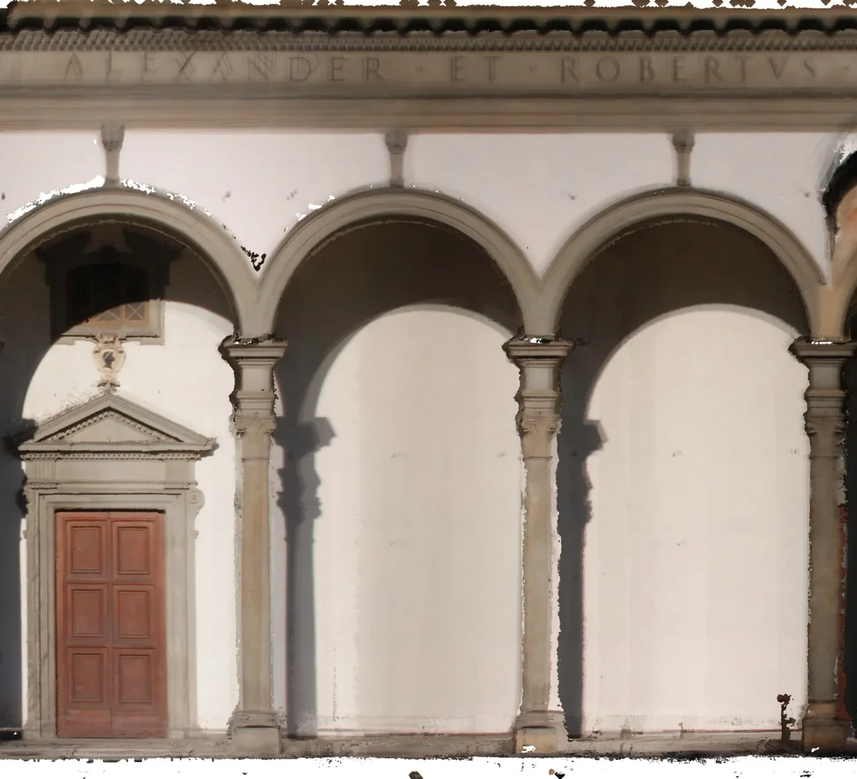
    Original photo of Santissima Annunziata Portico Elevation from an Orthophoto
    Elevation line drawing of three bays of the Renaissance portico of Santissima Annunziata, Florence, with its arches, columns, pedimented door and inscription

    Santissima Annunziata portico, Florence. Photogrammetry: E. Pellis et al., CC BY 4.0, adapted.

    Elevations from orthophotos

    A photogrammetric orthophoto of a portico. PhotoCAD draws the arches, columns, and doors, and reads the inscription.
    PhotoCADTimeAbout a minuteCost~$1 per drawingA clean first draft of each view, at real scale, on your sheet, as DWG, for your team to review and finish.
    1

    Export the views

    Export each plan, elevation, and section as an image: slices and orthographic views from your point-cloud software, orthophotos from photogrammetry, or scans of existing drawings.

  • PNG
    2

    Upload them to PhotoCAD

    PNG, JPG, or TIFF up to 150 MB each, one view per file. PhotoCAD drafts each view in about a minute.

  • 3

    Check the draft

    Compare each drawing with the image and the cloud. PhotoCAD drafts; your team’s review is what makes it a survey drawing.

  • 14.20 m
    4

    Scale from control

    Set the real size from a surveyed length, the longest one in the view.

  • 14.20 mOFFICED01
    5

    Annotate

    Add dimensions, room names, door and window tags, callouts, and notes, with leader arrows where they point to something.

  • MEASURED SURVEYDRAWN BYSCALE1:100
    6

    Your sheet, your title block

    Lay several views on one sheet at their own scales, add your title block, and download a DWG that opens at real size in AutoCAD or Revit.

  • Try it on one of your scans

    3 free conversions. No card required.

    Talk to us about a project
    PhotoCAD drafts in proportion to the image you upload; your team sets the scale from surveyed dimensions.
    ReviewPhotoCAD can occasionally misread a small feature or an illegible inscription, which your team’s check against the source catches before issue.
    DisclosureDescribe it as AI-assisted drafting from your scan data, checked by your team. The RICS standard on responsible use of AI asks members to tell clients in writing.
    DeliverablesDWG, DXF, SVG, and PDF: the linework on one layer, with your dimensions, labels, and title block on layers of their own.

    For your due diligence file: our AI supplier information sheet (PDF) answers the RICS standard’s supplier questions point by point, and the Trust page covers data handling, retention, and sub-processors in full.

    Hide the overlays

    Turn off measurements, cursors, grids, tags, and markers before export, so they stay out of the drawing.

  • Export at full resolution

    Use the highest resolution your software offers, then crop to the part you are drawing.

  • Scale from control

    The longest surveyed length in the view sets the scale best.

  • Partly. PhotoCAD puts the converted linework on one layer, with dimensions, labels, and the title block on layers of their own. Reassign the linework to your standard’s layers in CAD.

    PhotoCAD does scan to 2D: it drafts the floor plans, elevations, and sections from views of the scan, and the DWG opens in Revit at real size to work from alongside a BIM model. It does not build the 3D model itself.

    Yes. The PhotoCAD API converts images in bulk from your own scripts or software, with the same output as the website.

    Pay as you go, or a plan: $15 a month for 15 conversions, or Pro at $49 a month for 50, which adds real size, sheets, and annotation. For a whole office or high volume, contact us.